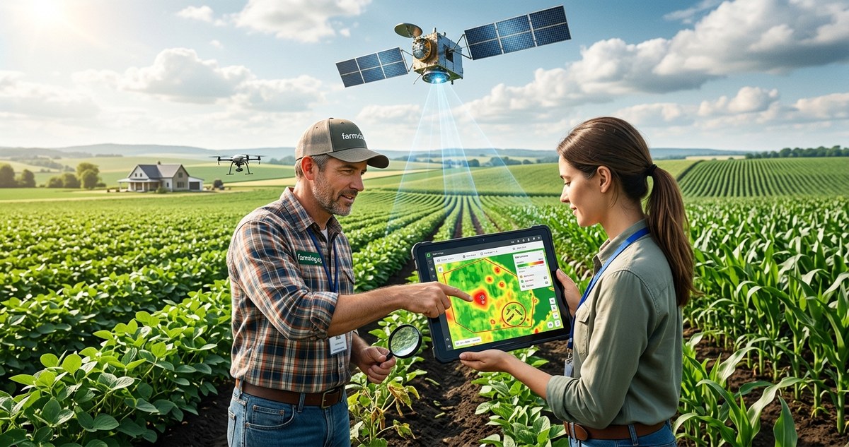
You are walking your fields and notice a few yellow leaves near the pivot corner. It could be a dry patch. It could be early thrips. But by the time you confirm a pest outbreak, that small spot might already span ten acres. In 2026, satellite imagery early pest detection has become a practical, everyday tool for farmers who want to stop infestations before they spread. The same eyes in the sky that used to be reserved for government agencies now deliver daily field views straight to your phone or laptop. And the best part? You do not need a degree in remote sensing to use them.
Satellite imagery for early pest detection works by spotting changes in plant health days before the naked eye sees them. Using vegetation indices like NDVI and AI-based pattern recognition, you can locate suspect zones, verify them in the field, and treat only the affected areas in 2026. This method reduces pesticide use, cuts scouting time, and protects yield potential.
Why Satellite Imagery Matters More in 2026
Pest pressure is evolving. Warmer winters and longer growing seasons have shifted insect life cycles across the U.S. Corn Belt, the Delta, and the Central Valley. At the same time, satellite technology has crossed a threshold. Where five years ago you might have gotten one clear image every 10 days, now constellations of small satellites (think Planet, Sentinel, and commercial providers) can revisit the same field every 24 to 48 hours. Resolution has improved to the point where a 3-foot pixel can show subtle color shifts in a single row. That resolution, combined with cloud-penetrating synthetic aperture radar, means you get usable imagery even when skies are gray.
For a farmer managing 2,000 acres, walking every field twice a week is impossible. Satellite imagery early pest detection lets you prioritize. You check a map, see a zone with an abnormal vegetation index, and scout only that spot. That saves hours and diesel.
How Satellites See Pests Before You Do
Healthy plants reflect near-infrared light strongly. Stressed plants do not. When a pest like spider mites or aphids starts feeding, the plant closes its stomata, changes its leaf structure, and reflects less near-infrared. Satellites measure that shift through indices like the Normalized Difference Vegetation Index (NDVI). A sudden drop in NDVI across a patch of field often signals a pest event.
But NDVI alone can be misleading. Drought, nutrient deficiency, and herbicide drift produce similar signatures. That is why modern platforms layer in additional bands: red edge for chlorophyll content, shortwave infrared for water content, and thermal for temperature. An AI model then compares the pattern against known pest signatures.
A Three-Step Process to Start Using Satellite Imagery for Early Pest Detection
-
Choose a subscription service that fits your crop and region. Most precision agriculture software platforms now include satellite subscriptions. Look for one that offers 3-meter or better resolution, at least a daily revisit, and a pest-specific anomaly alert. Services like FarmDog, Corteva FieldView, and Climate FieldView offer integrated modules. Set your field boundaries and crop type in the dashboard.
-
Configure your alert thresholds. Do not just stare at raw NDVI maps. Set an alert that triggers when a zone of at least half an acre drops more than 15% in NDVI compared to the surrounding area. Adjust the threshold based on your crop growth stage. Young corn is more sensitive than mature wheat. The alert should send a push notification to your phone, not a weekly email.
-
Ground-truth every alert. Satellite imagery is a screening tool, not a diagnosis. When you get an alert, walk to that specific GPS coordinate. Take a leaf sample. Confirm whether the stress is from aphids, fungal disease, or just a compaction zone. If it is a pest, use the coordinates to program a variable-rate sprayer and treat only the affected polygon.
What to Look for in Your Satellite Pest Detection Reports
- A sudden, jagged edge of low NDVI along a field border (often indicates armyworm migration from a ditch).
- Circular or irregular patches of declining vegetation that grow in diameter over two consecutive revisits (suggesting a root feeder like corn rootworm larvae).
- A streak pattern aligned with prevailing wind direction (indicates airborne pests like thrips or mites).
- Low NDVI in spots that follow the same pattern as previous years (means a chronic pest hotspot).
Common Pests and Their Spectral Signatures vs. False Alarms
| Pest or Condition | Typical Spectral Pattern | Common Misdiagnosis |
|---|---|---|
| Soybean aphid | Diffuse yellowing on upper canopy, NDVI drop over 3-5 days | Nitrogen deficiency (but N deficiency is more uniform) |
| Spider mites | Speckled bronzing in hot, dry areas; red-edge index shift | Water stress (but mites show distinct speckling at leaf level) |
| Corn earworm | Irregular, progressing from field edges inward; mid-season | Leaf fungus (fungus often starts lower canopy) |
| Fusarium head blight (wheat) | Scattered, bleached spikes, NDVI drop in heads | Premature ripening (check spike color manually) |
| Herbicide drift | Sharp rectangular or spray-pattern low NDVI | Pest damage (drift edges are straighter than pest fronts) |
The table above highlights why satellite imagery early pest detection requires cross-referencing. A confident pest alert combines a vegetation index anomaly with a temporal pattern (how fast it spreads) and a spatial pattern (shape and location).
Expert Advice: Let the Satellite Guide Your Boots
“I tell growers the same thing every season. The satellite map is your second pair of eyes, but your boots are still your first pair of hands. When you get an alert, do not spray until you have seen the pest with your own eyes. The best satellite image in the world cannot tell you if it is 200 aphids per plant or 2,000. That difference changes your treatment decision.”
– Mark Johansson, agronomist with 30 years in Midwest row crops
That advice is especially true in 2026 because insecticide resistance is rising in some regions. Applying the wrong product or the wrong rate can accelerate resistance. Satellite imagery helps you act early, but only ground scouting tells you exactly what you are fighting.
Combine Satellite Data with Other Smart Farming Tools
Satellite imagery works best when integrated with other data sources. Pair it with digital soil sensors to separate pest stress from moisture stress. If a low NDVI zone also shows higher soil moisture than the surrounding area, root rot or a soil pest is more likely. If moisture is normal, suspect a foliar pest.
You can also feed satellite alerts into an AI-powered crop management platform that combines weather forecasts, pest life cycle models, and your field history. That system can predict whether an aphid hotspot will explode or fizzle, helping you decide to treat now or wait.
For larger operations, combine satellite scouting with drone technology for confirmation. A drone can fly the suspect polygon that same day and capture centimeter-scale images. That two-step workflow (satellite flags, drone confirms) is becoming standard in 2026 for high-value crops like almonds and wine grapes.
Common Mistakes That Ruin Your Early Detection Results
- Using the same threshold for all crops. Corn and cotton respond differently to stress. Customize each field.
- Ignoring the time of day. Satellite images taken at different sun angles can create false NDVI drift. Stick to images from the same pass time or use normalized products.
- Not accounting for cloud shadows. A shadow looks like a stress patch. Use a service that masks clouds and shadows automatically.
- Waiting for the alert to reach “critical” level. By then the pest has already reproduced. Set alerts for early stages.
- Forgetting to update field boundaries when you rotate crops. A corn field that becomes soybeans will have a different baseline.
The Big Gain: Lower Costs and Higher Precision
Using satellite imagery for early pest detection is not just about protecting yield. It directly saves money. When you spot an infestation early, you can treat a 2-acre patch instead of an entire 80-acre quarter section. That cuts chemical costs, reduces application time, and lowers the environmental footprint. In 2026, several input cost studies show that farmers who use satellite-based scouting reduced their insecticide spend by 20 to 35 percent while maintaining the same yield.
For row crop farmers, that translates to real per-acre savings. For specialty crop growers, it means avoiding the complete loss of a block. The return on investing in a satellite subscription (often $3 to $8 per acre per year depending on resolution and frequency) is obvious after one season.
Your First Satellite Monitoring Season
If you are new to satellite imagery, start small. Pick one field that has a history of pest pressure. Sign up for a free trial of a platform like FarmDog or use the basic NDVI layer in your existing farm management software. Set a weekly reminder to check the map on Tuesday and Friday mornings. When you see a suspicious zone, walk it and take notes. By the third week, you will start recognizing patterns.
Within a single growing season, you will notice that pests rarely start in the middle of a field. They usually begin near waterways, tree lines, or weedy headlands. Satellite imagery confirms those hot spots early. Once you see that pattern, you can scout those edges proactively even before the next alert.
The technology in 2026 is ready. The question is whether you are ready to let a satellite do some of the heavy lifting. Try it on one field this season. The worst that can happen is you confirm your existing scouting approach is solid. The best is you catch a pest before it costs you a bushel.
And honestly, which farmer would not want that edge?